Journal article · 2026
Vision-based UAV Altitude Estimation using Deep Learning: A ResNet50 Approach on Nadir Images
Turkish titleDerin Öğrenme ile Görüntü Tabanlı İHA İrtifa Tahmini: Nadir Görüntüler Üzerinde ResNet50 Yaklaşımı
Academic Platform Journal of Engineering and Smart Systems, 14(1), 46–54
- Year
- 2026
- Publication date
- Journal or conference
- Academic Platform Journal of Engineering and Smart Systems
- Volume
- 14
- Issue
- 1
- Pages
- 46–54
Abstract
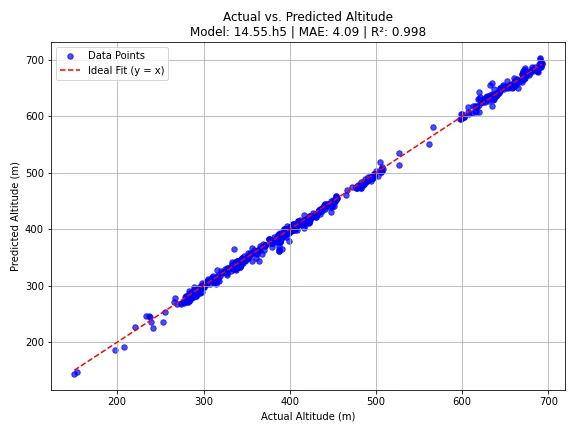
This study proposes a vision-based deep learning approach for unmanned aerial vehicle (UAV) altitude estimation as an alternative to traditional methods such as GPS, barometric sensors and laser altimeters, which are often sensitive to environmental disturbances. A large-scale dataset of 303,710 nadir images was collected using Mavic 2 Pro and Mavic 2 Zoom platforms under diverse weather, illumination and terrain conditions. Each image was labelled with above-ground-level altitude by integrating EXIF-based GPS altitude with a 30 m digital elevation model through coordinate transformation and terrain subtraction. A pretrained ResNet50 model was reconfigured as a regression network and fine-tuned for 200 epochs using the Adam optimiser and mean squared error loss. The model achieved a mean absolute error of 4.09 m in urban areas and 6.06 m in rural areas, with R² scores of 0.9981 and 0.9804, respectively.
Keywords
Core method
Transfer learning with a pretrained ResNet50 adapted for regression; EXIF and DEM-based altitude labelling; rotation, scaling, cropping and resizing for data preparation.
Data used
303,710 nadir images captured with Mavic 2 Pro and Mavic 2 Zoom platforms under varied terrain, weather and illumination conditions. Above-ground-level labels combine EXIF GPS altitude with a 30 m DEM.
Verified key results
- Urban MAE: 4.09 m; R²: 0.9981
- Rural MAE: 6.06 m; R²: 0.9804
APA citation
Arık, A. E. (2026). Vision-based UAV altitude estimation using deep learning: A ResNet50 approach on nadir images. Academic Platform Journal of Engineering and Smart Systems, 14(1), 46-54. https://doi.org/10.21541/apjess.1730867
BibTeX
@article{Arik2026UavAltitude,
  author  = {Arık, Ahmet Ertuğrul},
  title   = {Vision-based UAV Altitude Estimation using Deep Learning: A ResNet50 Approach on Nadir Images},
  journal = {Academic Platform Journal of Engineering and Smart Systems},
  year    = {2026},
  volume  = {14},
  number  = {1},
  pages   = {46--54},
  doi     = {10.21541/apjess.1730867}
}